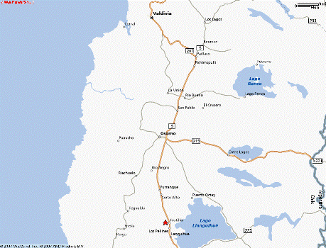
Frutillar
Sunday November 11, 2007
We left Validivia two days ago to drive to Frutillar. Frutillar is located on the western shore of Lago Llanquihue, the largest in the Lakes District, second largest in Chile, and third largest in South America (Titicaca is #1).
Click the map if you want to zoom or pan the Mapquest map of Frutillar, Chile...
We could have made the drive with a short blast down the Panamerican, but tried to head inland a few lakes north of Llanquihue and then work our way southward on the un-paved "Ruta de los Lagos." A paved and well marked road took us to Lago Ranco, but then a confusing set of contradicting signs led us not to our desired destination (two other large lakes in a national park with a couple more massive volcanoes), but onto a deteriorating, rutty path that an old farmer confirmed would eventually take us nowhere. By the time we had slowly retraced our errant path back to a place we could identify on one of our maps, it was after 5pm and time to head towards that blast down the Panamerica. So we missed out on another couple of lakes and the biggest waterfall in Chile, but we did get this precious picture of Lago Ranco:
Frutillar, along with most of the villages and farms surrounding the southwestern corner of Lago Llanquihue, was settled and developed by German immigrants in the late 19th century. That history is still readily apparent in the architecture of the buildings and menus in the restaurants.
Yesterday we worked on fixing the truck window leak in the late morning, and then walked along the lake to lunch at a cafe in the new performing arts and exhibition hall (under construction) before visiting the outdoor Muséo Colonial Alemán (German Colonial Museum). In the late afternoon we snacked on kuchen and strudel at one of the many tea houses along the lake.
Looking along the shore of Lago Llanquihue from our hotel - the view spans the length of the small village of "Frutillar Bajo." "Frutillar Alto" is about a kilometer up the hill.
The new arts center.
View from the grounds of the German colonial museum.
The "casona" - house of the plantation owners.
Kitchen Dining Room
Salon
Bedrooms
Original settlers...
and one of their graves.
Barn/Workshed.
Various manual machinery in the barn.
Waterwheel driven mill.
Back on the streets of Frutillar.
One of the more elegant old houses.
Chile has some of the larges bumblebees in the world, so we couldn't resist trying to take their pictures. It was difficult to get them to pose, however.
Here is that huge rhubarb-looking plant that we see vendors selling on the street all the time.
The immense Volcan Osorno looms over the eastern shore - but we could never see the top. No matter how sunny it was in Frutillar, clouds clung to the summit of Volcan Osorno.
Today we drove south along the lakeshore to Puerto Veras, a rival "adventure sports" center to Pucón, where we lunched, shopped a book fair, took our late afternoon "onces" (Chilean for "tea time"), and then drove around hunting for a decent vantage point to shoot photos of the large old church, originally built for German Jesuits.
Tomorrow we head for a cabaña near the mouth of the Cochamó river. Further upstream, the Cochamó valley is proclaimed to be (by the proprietors of the cabaña) "The Yosemite of Chile." We'll see how Yosemite-like it is when we get there, and whether or not the truck still leaks the next time it rains!